
The warm days are getting hotter: 'Much stronger increase than average'


It is hot in the Netherlands, that is not lost on anyone. Warm days are getting hotter, they are warming up more than days that are less warm. In a world that is 1.5 degrees warmer than now, today would not be around 35 degrees, but around 38 degrees.
This is evident from a new method, called Future Weather, which can be used to look at weather extremes in the future. "We want to use this to make the weather of the future visible," says Geert Lenderink of the KNMI.
Not only regarding future heat, but also about other weather extremes, such as heavy precipitation, Future Weather can provide more information. Organizations, companies and politicians will then know better what to prepare for, Lenderink explains.

The method makes clearer what climate change means for the weather in the future. It can also show how the current weather has already changed due to the current warming. This also applies to weather extremes, such as a heat wave or a storm.
"With this model we can clearly see that the warming is not the same everywhere. Even within Europe there are big differences. In Central and Southern Europe it is happening faster than here," says Lenderink. In Southern Europe it can often remain hot for weeks, with temperatures above 35 or even 40 degrees.
Fast upIn the Netherlands, the trend towards more heat is more variable. This means that during a heat wave, temperatures can shoot up very quickly, but can also drop relatively quickly. If the wind starts blowing more from the west, as it often does in an average summer, it will cool down considerably.
The new method makes it possible to see what today's weather looks like in an even more heated world. Lenderink specifically investigated what today's temperature would be like in the future, and tomorrow's. "We do assume that there are exactly the same weather patterns as now."
Worst caseNot only was it examined what the temperature would be if the global average had risen by another 1.5 degrees, a worst case scenario of three degrees was also examined. This is added to the 1.3 degrees of average warming that the world has already experienced, compared to pre-industrial levels.
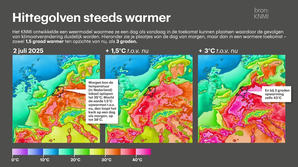
"With those three degrees extra, the picture becomes a lot more extreme: today it would be about 41 degrees, and tomorrow even 43 degrees," says Lenderink. The chance that this will actually happen is not great: the world is busy reducing greenhouse gas emissions, although the average emissions are still not decreasing.
Extremes in weather are therefore increasing more than the average. The reason for this is mainly due to the drying out of the soil in Southern Europe. High temperatures there cause more evaporation, and the soil dries out considerably. As a result, there is less cooling, because more moisture in the soil means less high temperatures.
Especially around the Mediterranean SeaThis process is mainly taking place around the Mediterranean Sea. That is why the Mediterranean area is also called a 'hotspot' of climate change: something that was also explicitly addressed in the latest report of the UN climate panel IPCC from 2021.
If the wind then blows from the south towards the Netherlands, it can also warm up very quickly here. And then there is the fact that the Netherlands itself also had to deal with a dry spring. The effect of a dry soil around the Mediterranean Sea occurs every year. What is special this year is that it leads to high temperatures so early in the summer season.
How can you say anything about the climate of the future, if the weather forecast for next week is sometimes not entirely correct? The big difference between the two is that a weather forecast is about the weather a few days ahead, while a statement about climate change says something about the average weather in the future.
Compare it to a statement about the weather in February or August: it is still uncertain what the temperature will be on August 1, but it is clear that it is on average warmer than on February 1.
RTL Nieuws


